
(aka Features that ArcGIS Desktop users might not know that exists)
EN | PT
From time to time, I read articles comparing ArcGIS vs QGIS. Since many of those articles are created from an ArcGIS user point of view, they invariably lead to biased observations on QGIS lack of features. It’s time for a QGIS user perspective, so bare with me on this (a bit) long, totally and openly biased post.
“Hello, my name is Alexandre, and I have been using… QGIS“
This is something I would say at an anonymous QGIS user therapy group. I’m willing to attend one of those because being recently and temporally forced to use ArcGIS Desktop again (don’t ask!), I really really really miss QGIS in many ways.
There was a time when I have used ArcGIS on the regular basis. I used it until version 9.3.1 and then decided to move away (toward the light) into QGIS (1.7.4 I think). At that time, I missed some (or even many?) ArcGIS features, but I was willing to accept it in exchange for the freedom of the Open Source philosophy. Since then, a lot have happened in the QGIS world, and I have been watching it closely. I would expect the same have happened in ArcGIS side, but, as far I can see, it didn’t.
I’m using top shelf ArcGIS Desktop Advanced and I’m struggling to do very basic tasks that simply are nonexistent in ArcGIS. So here’s my short list of QGIS functionalities that I’m longing for. For those of you that use ArcGIS exclusively, some of this features may catch you by surprise.
Warning: For those of you that use ArcGIS exclusively, some of this features may catch you by surprise.
Transparency control
“ArcGIS have transparency! It’s in the Display tab, in the layer’s properties dialog!”
Yes, but… you can only set transparency at the layer level. That is, either it’s all transparent, or it’s not…
In QGIS on the other end, you can set transparency at layer level, feature/symbol level, and color level. You can say that this is being overrated, but check the differences in the following images.


Notice that in QGIS you can set transparency at color level everywhere (or almost everywhere) there is a color to select. This includes annotations (like the ones in the image above), labels and composers items. You can even set transparency in colors by using the RGBA function in an expression! How sweet can that be? 🙂

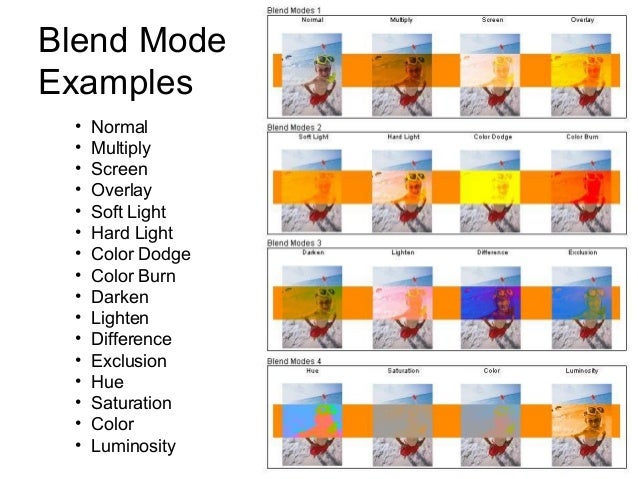
Blending modes
This is one of QGIS’s pristine jewels. The ability to combine layers the way you would do in almost any design/photo editing software. At layer or at feature level, you can control how they will “interact” with other layers or features below. Besides the normal mode, QGIS offers 12 other blending modes: Lighten, Screen, Dodge, Darken, Multiply, Burn, Overlay, Soft light, Hard light, Difference, and Subtract. Check this page to know more about the math behind each one and this image for some examples
It’s not easy to grasp how can this be of any use for cartography before you try it yourself. I had the chance to play around while trying to answer this question.

A very common application for this functionality is when you want to add shadows to simulate the relief by putting a hill shade on top of other layers. In ArcGIS, you can only control the layer transparency, and the result is always a bit pale. But in QGIS, you can keep the strength of the original colors by using the multiply mode in the hill shade layer.


You can also use blending modes in the print composer items, allowing you to combine them with other items and textures. This gives you the opportunity to make more “artistic” things without the need to go post-processing in a design software.
Colour Picker Menu
Controlling color is a very important deal for a cartographer and QGIS allow you to control it like the professional you are. You can select your colours using many different interfaces. Interfaces that you might recognize from software like Inkscape, Photoshop, Gimp and others alike.


My favorite one is the color picker. Using color picker, you can pick colors from anywhere on your screen, either from QGIS itself or outside. This is quite handy and productive when you are trying to use a color from your map, it’s legend, a COLOURlovers palette or a company logo.

You can also copy/paste colors between dialogs, save and import color palettes, and you can even name a color and use it in a variable. With all this available for free, it’s hard to swallow Windows color selector :(.


Vector symbols renderers “powertools”
In ArcGIS, you have a few fancy ways to symbol your vector layers. You got: Single symbol, Unique values, Unique values many fields… and so on. At the first glance, you may think that QGIS lacks some of them. Believe me, it doesn’t! In fact, QGIS offers much more flexibility when you need to symbol your layers.
For starters, it allows you to use fields or expressions on any of the symbols renderers, while ArcGIS only allows the use of fields. Powered by hundreds of functions and the ability to create your owns in python, what you can do with the expression builder has no limits. This means, for instance, that you can combine, select, recalculate, normalize an infinite number of fields to create your own “values” (not to mention that you can tweak your values labels, making it ideal to create the legend).

And then, in QGIS, you have the special (and kinda very specific) renderers, that make you say “wooooh”. Like the Inverted polygons that allow you to fill the the outside of polygons (nice to mask other features), the Point displacement to show points that are too close to each others, and the Heatmap that will transform, ON-THE-FLY, all your points in a layer into a nice heatmap without the need to convert them to raster (and that will update as soon as you, or anyone else, edits the point features).

But I have left the best to the end. The “One rendered to Rule them all”, the Rule-based symbols. With the rule-based renderer, you can add several rules, group them in a tree structure, and set each one with a desired symbol. This gives QGIS users full control of their layer’s symbols, and, paired with expression builder and data-defined properties, opens the door to many wonderful applications.

Atlas
One of my favorite (and missed) features in QGIS is the Map Composer’s Atlas. I know that ArcGIS has its own “Atlas”, the Data Driven Pages, but frankly, it’s simply not the same.
I believe you know the basic functionally that both software allow. You create a map layout and choose a vector layer as coverage, and it will create an output panned or zoomed for each of the layer’s feature. You can also add some labels that will change according to the layers attributes.
But in QGIS, things go a little bit further…
Basically, you can use coverage layer’s attributes and geometry anywhere you can use an expression. And, in QGIS, expressions are everywhere. That way, most layers and map composer items properties can be controlled by a single coverage layer.
With the right configuration, while iterating over the atlas coverage features, you can, choose what feature to show and what features to hide, change a theme color for your map, rotate and resize your page acording to the feature size, choose a specific logo to came along with your map, and much more. Once again, the sky is the limit.

So, if you pair Atlas it with QGIS data-defined properties, rule-based symbols and expressions, ArcGIS Data Driven Pages are no match. You don’t think so? Try to answer this question then.
Tip: If you really want to leverage your map production, using Spatialite or Postgis databases you can create the perfect atlas coverage layers from views that fit your needs. No data redundancy and they are always updated.
Label and Style dialogs
This one is more of a User Experience thing than an actual feature, but you won’t imagine how refreshing it is to have all Style and Labels options in two single dialogs (with several tabs, of course).
Using the symbol menu in ArcGIS makes me feel like if I’m in the Inception movie, at some point in time, I no longer know where the hell am I. For example, to apply a dashed outline in a fill symbol I needed to open 5 different dialogs, and then go back clicking OK, OK, OK, OK …

In QGIS, once in the properties menu, every setting is (almost) one click way. And you just need to press OK (or Apply ) once to see the result!

As an extra, you can copy/paste styles from one layer to another, making styling several layers even faster. And now you say:
“Don’t be silly! In ArcGIS you can import symbols from other layers too.”
Symbols? yes. Labels? No! And if you had lots of work setting your fancy labels, having to do the exact same/similar thing in another layer, it will make you wanna cry… I did.
(I think I will leave the multiple styles per layer vs data frames comparison for another time)
WFS
“Say what?!!”
Yup, that’s it, ArcGIS Desktop lacks support for WFS OGC standard unless you buy an extra extension: The Data Interoperability Extention.
In a GIS world that, more and more, is evolving towards Open Data, Open Standards and OGC Web Services, this reveals a very mercantile approach by ESRI. If I were an ESRI customer, I would feel outraged. <sarcasm>Or maybe not… maybe I would thank the opportunity to yet invest some more money in it’s really advanced features…<\sarcasm>
In QGIS, like everything else, WFS is absolutely free (as in freedom, not free beer). All you need to do is add the WFS server’s URL, and you can add all the layers you want, with the absolute sure that they are as updated as you can get.

Fortunately for ArcGIS users with a low budget, they can easily make a request for a layer using the internet browser :-P.
http://giswebservices.massgis.state.ma.us/geoserver/wfs?request=GetFeature&service=wfs&version=1.0.0&typename=massgis:GISDATA.TOWNS_POLY&outputformat=SHAPE-ZIP
Or they can simply use QGIS to download it. But, in both cases, be aware that the layers won’t update themselves by magic.
Expression builder
I have already mentioned the use of expressions several times, but for those of you that do not know the expression Builder, I though I end my post with one of my all time favourite features in QGIS.
I do not know enough of ArcGIS expression builder to really criticize it. But, AFAIK, you can use it to create labels and to populate a field using the field calculator. I know that there are many functions that you can use (I have used just a few) but they are not visible to the common user (you probably need to consult the ArcGIS Desktop Help to know them all). And you can create your own functions in VBScript, Python, and JsScript.

On QGIS side, like I said before, the Expression Builder can be used almost everywhere, and this makes it very convenient for many different purposes. In terms of functions, you have hundreds of functions right there in the builder’s dialog, with the corresponding syntax help, and some examples. You also have the fields and values like in ArcGIS, and you even have a “recent expressions” group for re-using recent expressions with no the need to remember prior expression.

Besides, you can create your own functions using Python (no VBScript or JsScript). For this purpose, you have a separate tab with a function editor. The editor have code highlighting and save your functions in your user area, making it available for later use (even for other QGIS sessions).

Conclusion
These are certainly not the only QGIS features that I miss, and they are probably not the most limiting ones (for instance, not being able to fully work with Spatialite and Postgis databases will make, for sure, my life miserable in the near future), but they were the ones I noticed right away when I (re)open ArcGIS for the first time.
I also feel that, based on the QGIS current development momentum, with each QGIS Changelog, the list will grow very fast. And although I haven’t tested ArcGIS Pro, I don’t think ESRI will be able to keep the pace.
“Are there things I still miss from ArcGIS?” Sure. I miss CMYK color support while exporting maps, for instance. But not as much as I miss QGIS now. Besides, I know that those will be addressed sooner or later.
In the end, I kinda enjoyed the opportunity to go back to ArcGIS, as it reinforced the way I think about QGIS. It’s all about freedom! Not only the freedom to use the software (that I was already aware) but also the freedom to control software itself and it’s outputs. Maintaining the users friendliness for new users, a lot have been done to make power users life easier, and they feel very pleased with it (at least I am).
All this being said, the winner is… QGIS!!

Great post – love it! I always feel the same when I read those “QGIS vs ArcGIS” comparisons, so it’s refreshing to hear the alternative view.
LikeLike
I would love to see a book about cartography wrote with 4 hands by Alexandre and Nyall
LikeLiked by 1 person
🙂
LikeLike
WFS is available for free.
WFS connections and GML (simple features profile) reading/writing are enabled without licensing the Data Interoperability extension, but installation is required.
LikeLike
Hello Mark, where can I read about that?
LikeLiked by 1 person
what do you mean by installation?
LikeLiked by 1 person
Mark is correct. There are a few limited features you can use in the Data Interoperability Extension without needing to purchase the license. Among these is READ-ONLY access to WFS services.
http://desktop.arcgis.com/en/desktop/latest/map/web-maps-and-services/adding-a-wfs-service-to-arcmap.htm
Unfortunately it seems that most folks at Esri support are not even aware of this. If you ask them about WFS they will tell you you need to purchase the extension.
LikeLike
Thank you for sharing. I will update the post ASAP. But notice that even the link you have sent says at the beginning “Available with Data Interoperability license”. Easy for anyone to make a mistake about it. I will try it myself (Not sure if I can remove or turn off the interoperability license).
LikeLike
Hello,
very nice article. We need more of them to show that QGIS is a complete professional GIS tool.
QGIS is really superior to ArcMap 10.x on the dialog boxes an we need to keep this true. When you only need one or two clicks in QGIS, you need to open 3 dialogs and click on 5 buttons to do the same in ArcMap.
You also have to remember (or learn) that ArcMAP is only a 32bits application and as far as I can see, it can only use one processor core at a time. Compared to the 64bits multi-threaded rendering engine of QGIS, ArcMap is very often slower than QGIS ! That’s why ESRI is building another/new desktop tool: ArcGIS Pro (and it uses Qt).
For the moment, I think that there are much more (about 1k) unique geo-algorithms in ArcGIS, compared to QGIS Processing. But we get more and more Processing algorithms with each QGIS release. If we keep a constant development effort on Processing, I am sure than in less than 5 years, we will have more algorithms than in ArcGIS.
Thanks to the QGIS devs and users that are struggling every day to make the best GIS software ever made !!!
LikeLiked by 1 person
Thanks.
Yes I really feel that we need to advertise the things QGIS is good at.
And QGIS has many unique and very useful features that you won’t find elsewhere. No post would be enough to describe them all.
There are many GIS users that the only impression they have about QGIS was formed a few years ago, still in 1.X versions. A lot have changed, we need to tell it to the world.
LikeLike
Thanks Alexandre. A lot of really good tips here – the blending functionality is great.
LikeLike
Thanks Alexander. .really very good article. .
LikeLike
I left ArcGis at 9.2. Your post brings back memories – being lost in the plethora of dialogue boxes, all looking nearly the same, to change the style etc.
Also at 9.2 the transparency wasn’t reflected in the legend….bonkers!
The Layout Composer is a bit behind – doesn’t work quite like most graphics programs and ArcGis, but is still very useable.
Keep up the good work evryone. And don’t forget to donate!
LikeLike
Just learning QGIS, this is really helpful. I want an “examples” button in QGIS (when using expressions and python).
LikeLike
Great work! Have you seen Anita Graser & Gretchen Petersen’s Cartography w QGIS book just released
http://www.amazon.com/QGIS-Map-Design-Anita-Graser/dp/0989421759/
LikeLike
I have! I will buy one for myself.
LikeLike
A couple of observations about this article:
1. Almost all (if not all) of the things above can be achieved in ArcGIS Desktop. Much like QGIS, you just need to know where to find them, or the series of steps you need to make to achieve the same result.
2. Go and check out ArcGIS Pro – I think you’ll find major UX and workflow improvements.
3. I presume this is a result of the author’s area of interest, but all of the issues noted are specific to high end cartography use cases. This overlooks a massive part of the user base (of both products), and the fact that with a single ArcGIS Desktop license you get capability to support basic mapping, high end cartography, web maps and custom web apps, advanced spatial analysis, publishing geoprocessing tasks for nonGIS users and apps, mobile field data collection and field crew enablement, 3D visualisation in desktop, mobile and web, an out of the box open data platform… the list goes on. Sometimes it’s worth paying for a great product.
LikeLike
Hello,
1. Please share the knowledge. I hope I won’t have to work with ArcGIS again, but we never know… I would very much like to know how to bypass those difficulties;
2. I don’t not have time to check ArcGIS Pro. I only heard some rumours about it. It’s good to know that ArcGIS users can finally use all their computers memory in a 64 bit version, have multiple map layouts in one project, etc…. But for what I have heard, processing is still done on good old 32 bit ArcGIS Destop (the subPro I guess);
3. You are right. Most of the features are Cartography related (I would not call it high end though). Like I have explained in the end of the post, those were the first things that I have missed (I was doing some maps), but I could (and probably will) do a second post with other features that I miss. This post was not intended to be a ArcGIS vs QGIS thing (there are plenty of those out there), but instead to highlight some features that ArcGIS does not seem to have.
We all know that ArcGIS is a huge software with tons of features, but it comes with a heavy price tag on it (and a huge chain). The software is delivered in price tiers. So if you pay good money for the first tier you get bunch of features, many of them you may never use and others may be missed (you may need to buy the 2nd tier). When you spend so much money in a software you may find difficult to untangled yourself from it. You will end up spending always more to keep the wheel spinning (open data or files from a newer version, get a co-workers to give you a hand, etc…).
I won’t go that road. Until now my FOSS4G tool set allowed me to do everything I needed (and I’m quite demanding). And, for me, more than the price or the number of features, it’s all about freedom. ESRI (or other proprietary model company) can’t offer me that.
LikeLiked by 2 people
Here’s a response to another list also comparing Q & A:
“Suggest u add Hexagon Geo esp to integrate remote sensing etc., but more importantly their lic. rental model.
Otherwise they [Q & A] leapfrog each other, n server models are a whole kettle if fish i suggest u address.
Even if, ti paraphrase Mark Twain, rumors of desktop’s death have been greatly exaggerated…”
LikeLike
Alexandre, great, great article.
I also feel QGIS is becoming a benchmark for gis desktop.
From esri only arcgis pro will be a contender, since arcmap is frozen in time, and receives only small improvements/corrections.
Even if some things you refer are somehow doable in arcmap (label manager to copy/paste label settings, and image effects http://arcg.is/WdEcD3), I’m adding a few items to your list that qgis does and arcmap does not:
1 – antialias – simple, not fancy, on-screen antialiasing of the map. very nice in qgis, non-existant in arcmap.
2 – multi-threaded map rendering – arcmap will only use 1 core, so your spectacular workstation will be 85% idle while you wait. qgis is super-fast and uses as many cores as you let it (configurable).
3 – multiple layouts in 1 project!! sounds unbelievable, but it’s true! you get 1 layout per project in arcmap. for decades users have been asking for this, decades!
4 – round corners in layout! forgetaboutit! you can have a map with round corners, but you cannot add a rounded image… what?? you can try but you will fail! support for transparencies in images are buggy.
5 – and the cherry on top of the cake: you shall not label polygons using the automatic calculated area! this is a bug since 10.3 – we gone through 10.3.1, and now 10.4… 15 months and unable solve a basic gis feature!
wew… this was cathartic!
LikeLiked by 1 person
🙂
LikeLike
Great.
I am in the same situation, ArcGIS again after some years of QGIS. Porting a tutorial on Hydrological analysis from QGIS to ArcGIS, I had the clear revelation that QGIS is far better…
LikeLike
But GIS is mutch more than an desktop tool, we need to integrate with other applications, we need to be mobile, we need to be on the web. Just comparing QGIS with ArcGIS Desktop is not very useful. When is see ArcGIS as a platform it is more then a desktop tool
LikeLike
Well, I was in fact comparing the desktop tools only, which were what I was using at the time. But if I decide to follow your advice, I could talk about QGIS server or geoserver paired with openlayers or leaflet for web. I could talk about Qfield and Roam as mobile solutions. We could talk about GeoNode as a ready-to-use sharing platform. Any of this tools are great to integrate with other systems. Why? Because they are free, open source, and comply with interoperability standards. Besides, all these tools are multi-platform. No proprietary GIS software can beat that. And not definitely none of ESRI products. Unless you have no love for your money and your freedom.
LikeLike
I’m not a GIS expert but a simple user interested in. I first try ArcGIS and was lost in so many anti-intuitive function and windows, couldn’t do what I wanted and was so frustrated. Then I tried Qgis, and not only did I find it intuitive but also so much faster at rendering mbtiles, not to mention the price…
I simply don’t understand why I would pay for something less intuitive, more restrictive and overpriced whereas open source is here doing the job better for free. Thanks for your article ! I guess ArcGIS used to be a reference for too long without competition, and now they simply fail to offer value for money.
LikeLike
I see people commenting that ArcGIS Pro will be the new competitor. I have not used QGIS other than installing it and going through a few tutorials. I just finished the first training module for ArcGIS Pro and realized I cannot use it very easily offline. This is a huge problem for me because I work overseas in remote areas that have little or no Internet service. I tried the “use offline” mode but ESRI’s licensing system would not allow me to do so and it was virtually impossible to find out how to make it work through the online help/forums. Classic ESRI. I’m going to start teaching myself QGIS.
LikeLike
I love Qgis and don’t miss Arc at all really. The buggy nature of ESRI software and the fact that the tool you need is always behind a pay wall does my head in. Truthfully though if I had to do a large amount of geo-processing I always reach for FME, its just so much quicker and easier to do all my processing in. So Q is more of a data viewer for me.
LikeLike